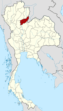
Uttaradit
Uttaradit sits in the transitional zone between central Thailand and the northern mountains, and it's best known for two things: the Laplae district's silk weaving and Thailand's finest langsat fruit. The annual Langsat Festival celebrates the sweet, translucent fruit with pageants, markets, and more langsat than you could eat in a month. Laplae itself is a charming valley town with traditional Lanna architecture, silk workshops, and a pace of life that hasn't changed in decades.
Wat Phra Thaen Sila At in the provincial capital houses a revered Buddha image, and the Si La At rock formation nearby is a natural curiosity. Sak Yai National Park has massive teak trees including the largest teak tree ever recorded in Thailand (now a preserved stump). The Nan River runs through the province with quiet riverside communities. Uttaradit is also the gateway to the Sirikit Dam, one of Thailand's largest reservoirs, with houseboat rentals and fishing. The province is firmly off the beaten path and rewards travelers who enjoy authentic small-town Thai experiences.